Level Up Design and Coordination Workflows with Accessible Reality Capture - Digital Builder
Level Up Design and Coordination Workflows with Accessible Reality Capture - Digital Builder
Picture this: your construction firm is looking to bid on a project to renovate an old factory into a new office building. The owner wants to preserve the structure’s historic look and feel while revamping the building’s internal layout and adding modern amenities.
It’s an exciting project, but it also comes with a host of challenges. For starters, you’re dealing with an old structure without CAD files and limited documentation. What’s more, the building is in a congested part of downtown, so there are a lot more area constraints and components to be mindful of.
Needless to say, trying to design, coordinate, and build in and around these conditions is an uphill battle. And this lack of proper contextual information on the jobsite can lead to poor decisions that result in errors or rework down the line.
This is a significant issue among many construction professionals, especially given the tight deadlines that firms must often work with. It’s no wonder 53% of contractors in the U.S. feel that time constraints and urgency present the greatest risk to decision-making.
The best way to navigate these challenges is to equip teams with data and tools that allow them to capture a site’s unique conditions and identify issues before they become major problems.
Having a competitive edge in BIM is helpful in this regard. But while BIM usage is growing, a good chunk of firms—59% based on our research—say that their workforce doesn’t have the skills needed to work with BIM.
To promote adoption, BIM and reality capture technology must be made more accessible and easy-to-navigate to construction teams.
Autodesk Construction Cloud meets reality capture
This is where the intersection of reality capture and Autodesk Construction Cloud comes in. Recap and Recap Pro users can now export NWC mesh files directly from laser scans or photogrammetry into Autodesk Docs. You can store and organize imported NWC mesh files using Autodesk Docs’ common data environment, enabling better data access and collaboration.
With reality capture files stored with the rest of the project data, stakeholders have quick access to the information they need to hit key milestones on time.
Reality capture is more accessible than ever
As far as the reality capture process itself, construction professionals will be pleased to know that the technology is more accessible and cost-effective than ever.
New mobile devices now have photogrammetry capabilities, so extracting 3D information from photos is much easier.
Arial photogrammetry has also become far less expensive in recent years. Ditto for drones; industry data shows that 63% of contractors use drones in their projects. Additionally, laser scanners are more ubiquitous and affordable than ever on jobsites.
Thanks to lower hardware costs and direct connections between tools, the process of creating usable 3D models from photos or laser scans is easier than ever. Teams can then design and move forward confidently, knowing they’re working with models that accurately reflect the site’s current conditions.
A better design and coordination workflow
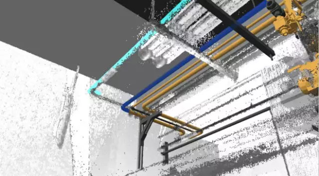
On the design and coordination side, VDC departments can augment their work with reality capture files to set a container file, measure existing conditions, aggregate and align with renovation models, and assign issues.
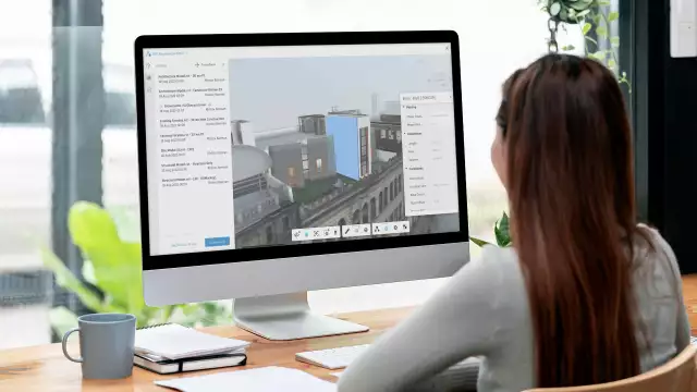
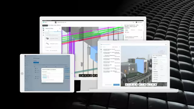
Reality Capture files in Autodesk Construction Cloud make it easier to do detailed clash tests using the Navisworks Add-In—which pulls down models, aggregates, and issues from the cloud to find construction errors before they hit the site. Stakeholders who are tasked with clash detection can do so using the Navisworks Add-In. That can pull down models, aggregates, and issues while running their own tests and assigning their own issues. Once an issue is created and assigned, it will populate throughout the issues eco-system in tools like BIM Collaborate, Build, and Revit.
In addition, mobile BIM technology allows on-site teams to check installation details so they can effortlessly navigate 3D models that now include a reality capture component. This is accomplished on a mobile device with gyroscope navigation, first person view, easy placement using 2D sheets, and more.
As the project progresses, leaders can take floor-by-floor laser scans to capture and document work being done or as-builts. To put this in context, think about the challenges of modernizing a historical structure when digital information isn’t readily available. Being able to track progress on-site provides a visual account of what was done in each phase of the project using laser scan snapshots. This simplifies the process of creating a comprehensive handover package containing all the necessary data during project closeout. In turn, owners have more details about their projects for operations, enabling contractors to ultimately win more work.
All of this makes it easier to track on-site progress when a model isn’t available, which means teams can navigate projects even under difficult site conditions and tight constraints. Reality capture files fuse existing conditions with project plans to deliver quality and consistency for even the most ambitious projects.
Let’s go back to that project…
At the start of this article, we presented a challenging scenario: modernizing an old building in a congested area—all while dealing with limited documentation and very little to no digital files.
It’s a tall order, but having user-friendly and cost-effective reality capture tools will make the project more manageable.
When you have reality files within Autodesk Construction Cloud, you can:
Now, as the project moves forward, you may encounter unforeseen challenges that require changes to the design. You can develop a cadence of tracking work by taking progressive laser scans as the project moves from floor to floor or phase to phase. By using laser scans to capture progress and changes for as-builts, you’ll be able to easily compare data and create more substantial handover packages.
Then when issues arise, you can simply assign them to teams in the field or engineers in Revit.
Autodesk Construction Cloud makes winning more work a reality
Autodesk Construction Cloud enables teams to implement reality capture and integrate it with design and coordination workflows. With these capabilities, you’re better equipped to deliver high-quality projects from start to finish—ultimately helping you win more work.
BIM Collaborate keeps your data, workflows, and team in one place so you can keep everyone connected, improve visibility, and drive higher project efficiency.
Learn more about BIM Collaborate.


![Tried and True Workflows for Precon/Prefab with BIM and Assemble [Webinar] - Digital Builder](https://realiff.com/assets/uc/Post/qE1l209sRHwa/thumbnail_default.webp?oOmitEynwoED)